
Land survey services form the backbone of informed property ownership, infrastructure planning, and...
Land Survey Services: The Data Quality Protocols Driving Smarter Feasibility and Due Diligence
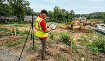
Every high-value land decision begins with one non-negotiable input: reliable data. Whether the objective is acquisition, development, or keeping it within the legal bounds, the accuracy of the survey data will have a direct impact on the assessments of feasible land usage and due diligence. This is where experienced local surveyors play a decisive role. With the help of their deep understanding of the site and the strictest data quality standards, they make sure that the measurements of the boundary lines, heights, rights of way, and claims against the property are all done with total accuracy and double-checked against the official records. In an environment where a single data point can lead to long waits for permits or increased risk, the use of disciplined survey techniques has transformed from being a technical formality to becoming the basis of making land decisions that are not only smarter and faster but also more defensible.
High-Accuracy Survey Protocols That Strengthen Early-Stage Project Decisions
To build safer structures and make informed investment choices, planning teams depend heavily on land survey services. Such services can change the raw site conditions into usable data that can be processed by engineers, architects, planners, and investors. This aims to eliminate assumptions and replace them with quantifiable evidence. Through organized survey plans, all decisions become more predictable, compliant, and project-specific.
Here are the essential data protocols that lead to smarter feasibility, stronger due diligence, and more resilient project planning.
-
Baseline Mapping That Establishes Verified Site Conditions
The foundation of a robust feasibility process is the precise baseline mapping rendered by the local land surveyors. They will consider the land's three-dimensional features, such as slopes, paths, vegetation, elevation changes, and natural obstacles. Basemap creation provides a reliable reference layer that is indispensable for architects to determine sizes and area possibilities. Planning teams can thus avoid common early-stage errors that occur when making decisions without ground-truth data. Confirmed base maps are validated and are thus a guarantee that the subsequent actions will reflect the actual site conditions.
-
Boundary Identification That Prevents Property Conflicts
Before any design or permitting process begins, legal boundaries must be verified by a trusted land survey company. Boundary disputes will lead to protracted delays, costs, and even legal tussles over property or a neighboring development. The surveyor identifies specific lines of boundaries, easements, setbacks, and common limits to avoid misunderstandings. The proper documentation of boundaries assists the smooth approval process, maintains the builders on the right track, and removes redundant work. This verification measure minimizes conflicts and helps protect the investor from legal problems.
-
Topographic Data That Enhances Infrastructure Planning
Once baseline conditions are established, topographic surveys move beyond site validation and into infrastructure optimization. This stage focuses on how landform variations directly influence the placement and performance of roads, utilities, stormwater systems, and access routes. Using high-resolution contour models and breakline analysis, experienced local surveyors provide engineers with actionable insights for grading strategies, cut-and-fill calculations, and drainage alignment. Rather than simply documenting terrain, this data enables design teams to minimize earthwork, improve constructability, and control long-term maintenance costs.
-
Elevation Measurements That Support Structural Stability
Structural performance depends on precise vertical control, making advanced land survey services essential for translating design intent into safe, buildable outcomes. Differences of height, line of contours, and ground variations are considered by the surveyors to determine foundation depth and grading requirements. Placing the correct elevation mappings aids in the establishment of flood-prone areas, low-lying pockets, and unstable slopes. The Accurate data on the elevation will allow project teams to come up with safer foundations, more robust retaining structures, and better load distribution. The given step provides long-term sustainability, and it helps avoid serious structural problems in the future.
Conclusion
Smarter project planning begins with accurate, validated land data. By working with trusted local surveyors, teams can have in-depth information that can be used to determine feasibility, aid compliance, and enhance due diligence. Verified borders, Topography information, elevation map, and utility search are all used to understand the site. Such insights enable developers to minimize risks and plan optimally, and prevent costly surprises during construction. Under good survey protocols, all projects proceed with clarity, surety, and reliably quantifiable confidence that will guarantee success in the long term for both the planners and investors.
For reliable surveying support that delivers accurate data and risk-free planning, contact Exacta Land today.

